


Topping the world!
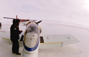
After engine start check completed!
Sure that everything is turned on?
Yeeees, so let us go.
Taxying was at low speed. Aircraft weight is there so no stress is necessary.
Flaps set to 10 degrees. At that setting, everything changes when heavy.
Communications at Resolute are just that: information. No clearances.
The sky is covered by a thin layer. Some ice will be present but just a little.
I have learned not to ask to much to my dear RV. I will just forward the throttle and let her to decide what to do.
After the engine check, I aligned the plane into the runway, and firewall forwarded the longest left lever.
The engine rev up quite well and acceleration was there. The stick, almost free, my hand was there just because it was better there than anywhere else.
She accelerated nicely and when she decided to do so, she lifted the tail and kept accelerating. Then, also when she decided to do so, she took off.
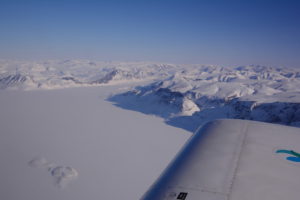
White was all around and I started to climb nicely until the base of the clouds.
Where is exactly the base of the clouds?
Well, it is like flying inverted very close to the ground: when we feel that the ground is running very fast next to the head, that means that we are very close.
I accelerated a little bit more (yes, I know, I forgot to fully retract the flaps) and pulled the stick back.
Soon I was ¨upright¨ over the new ground, and enjoying blue skies.
Flaps up? Flaps up! : next time I will punish myself!
A really little bit of ice blurred my rear video camera. Soon the speed cleaned the lens and I was able to record again the arounds.
Some 5000 feet and a Ground Speed of 140 kts, so a slight headwind was present.
As I did in the previous flight, I didn´t leaned the engine LOP (Lean Of Peak). I did it 50 F ROP
When an engine is leaned from full rich, exhaust temperature (EGT) start to increase, until the highest one is reached. That point is called the Peak.
If then we forward a little bit the mixture control, the temperature lowers also and we find ourselves at a Reach Of Peak (ROP) position.
If instead we back the mixture control from the peak, EGT decreases, and we find ourselves LOP.
Usually I fly LOP but I preferred to have the engine cylinders (CHT) at a good temperature. So I followed the advice to maintain 50F ROP to get the highest CHT (max power is got setting 100 F ROP, and minimum fuel at 50F LOP).
Main fuel tanks were loaded with Avgas. External wing tanks and forward tank loaded with Mogas.
Rear tank with a mixture of Mogas and Avgas.
First of all I switched the engine feed to the rear tank. That should be for just some four hours, the time to have the Center of Gravity (CG) ahead. Then I would use the forward tank and then the wing external tanks. Keeping the CG between limits is easy in this airplane.
The temperature was nice, just -17 C. I was prepared.
Water at the thermos was boiling. It is not easy to drink boiling water, so I just filled the top of the bottle, wait a few seconds and then drink the few cubic centimeters. Then again and again. Later on, the boiling water was to be even cold 1
The scenery was impressive. Not a video or photo camera can record that view and feelings !
By the time, flying the plane with the knees instead of the arms was already a procedure: I could use the hands for any other purpose !. The autopilot was not operating at 100%. No way to keep the roll, even when tracking the GPS.
Altitude hold was working nicely, so the problem was not the temperature (I thought that at the beginning and installed a heater around the autopilot), it was the system itself: my autopilot uses a magnetometer.
I was flying north (geographic north) and autopilot was telling me that I was tracking 070. If there was a track, why it didn´t follow it?
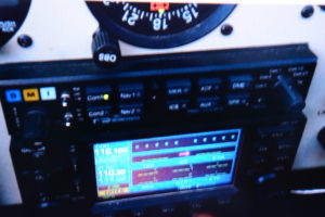
Ummmm, my Garmin 430 is tracking 070…… same than Autopilot…..
Autopilot is fed by the Garmin 430….
Ummmm, my Garmin 496 is tracking 094….
What the hell is going on?
Cornwallis Island, Iced sea, Cornwall island, sea, Axle Heiberg island and iced sea. What an incredible scenery.
Temperature was increasing and reached -8C !
The lines showed at the GPSs screens where the expected ones: A straight line into the North Pole, and another straight one forming around 120 angle direct to Longyearbyen.
Slowly, both GPSs were increasing their track indication. I was unable to understand how two GPS from the same brand would indicate different track.
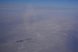
Magic did happens: the straight Garmin 496 from the North Pole ( sorry, from N 89 59 999) into Svalbard, was no longer a straight line. It was not even a curved line. Some two or three curved lines were present, like a fan.
The more I approached the Pole, the more the lines number started to increase: I was really surprised!!!
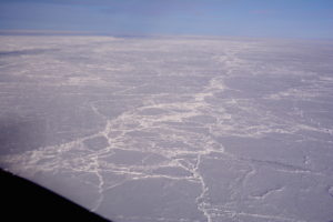
Artic sea is wonderful. Nice also to be frozen because would the engine fail, there was almost no water underneath, just a few cracks filled with blue water.
Temperature kept increasing even to -4 C !!!
It is true, the Pole is heating up and melting. The more I was flying into the north, the more cracks were visible.
The ice shell is not static: it is moving a little bit. Compression of the ice was present and also a fancy setoff. With a little of imagination, I was able to see cities, roads, and other features, white features.
Arctic Ocean
North Pole was already close. I was happy to have the Sun higher than the horizon and be able to see the clouds to avoid icing. I was flying around 7000 ft, and trying to track better the aircraft: I really wanted to overfly the North Pole itself.
I managed to take pictures of my GPS readings to record my own historic moment, also to fly the aircraft, to look outside to find Santa Claus´home.
The North Pole
Not the best and clean flight but ok.
I turned many time around the North Pole, as tribute to my top crowdfunders, somehow for them to fly round the world with me. Then I looked at the GPS indicated course..
My Garmin 496 was out with a huge cross right in the middle of the screen.
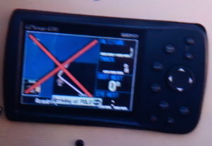
My Garmin 430 had all the information blanked and a kind message: Reset the system !
Both Ipad Airnav pros failed also !
Nice, I muttered myself ! Now what?
Good thing was that any heading would take me south.
Bad thing is that I don´t have any reliable heading.
Or I have?
Of course I have ! The Sun!
So I turned according its last position, to track some 120 degrees into the right and waited a few minutes.
Then I did reset the Garmin 430: even the satellite constellation was lost. Its start was similar to when you buy a unit in a country and start it in another country. It took a long time to reset.
No reset message was present at the 496 but it was treated the same way.
Nothing was possible to rescue my Navpro software: the system didn´t work until staying back in Madrid after many resets and deleting the software.
Garmin 430 was up again, but the depicted line into the destination was no longer a straight line, it was a curved line !
Same thing with the 496.
I was not able to see the earth map in both of the units so I was not sure if the information provided was right. Even though, what was the heading to be set? The first part of the curved line, or the one at the end of the path.
Was I going into Svalbard or into Alaska, or Russia?
I decided to create a new flight plan, a fast one. Next point would be Madrid. If the depicted line into Svalbard was more or less the same one into Madrid, I would consider that everything was right, and I could relax. The southern of my position, better the systems will work. Fortunately, the decisions proved to be right, so I could relax.
As I was approaching Svalbard, weather deteriorated. The clouds top started to be higher and it was necessary to climb.
Some three hours before reaching destination, I had to climb to 15000 ft, and there, it was cold indeed: temperature went down to -29C and my Iridium Sat phone failed. Also the Nikon camera stopped working (first the autofocus, and then the system).
Light was good enough to see and avoid.
Approaching Svalbard, I tried to find the openings, the ones you know, the ones for honest pilots.
Also I started to listen to the VHF frequency that Atle provided to me.
You are not going to receive it until very close to the airfield…
The truth is that the weather was not good at all. Finding my way between mountains in the middle of more than broken clouds was threatening. I was thinking myself about not being able to land there and fly to Tromso.
Like a God´s message, the VHF1 RX icon lighted On, and the magic voice of the Controller came into my headset
EC XLL, Longyear, do you receive me?
Of course, it was the moment to answer with a calm and professional voice, not with an exited one!
Weather at the airport was much better. It was just a matter of avoiding to enter areas without a clear exit path.
Soon, the sky opened and I was cleared for runway 10, with a welcome and the wish of a nice landing.
I turned my head to full power and tried to land safely. I did knew that relaxing when tired could be dangerous.
The area was beautiful, but I had to concentrate for the landing.
And then, there I was, safe and happy.
Then I could relax.
After landing at Longyearbyen
Many things have happened and I have to understand exactly what was going on with the GPSs.
Just a week ago, I realized what was the reason for the GPSs to show a different track, but I will not tell you now, because I want you to think about 🙂
I was happy to have arrived there, it was like feeling at home ( without heating, of course !).
6 Comments
For your different tracks on the GPSs you are not telling us if you were using true north (which is possible with the 430 and 496) or magnetic north.
It seems reading that the intial track to true north was 070 that you were still using magnetic reference,.
So it is possible that the variation tables in both GPSs were not the same, hence different magnetic tracks (but I suppose the headings were also different but consistent with the tracks).
It’s a pleasure to follow your adventure
Pascal
Hi Pascal
Thank you very much for your input.
In fact, although true headings are the best ones when navigating upper latitudes, I was using magnetic ones.
The reason is because I preferred to do it to check the compass behaviour (both the autopilot one and the wet one). It is true that magnetic inclination is not such a big concern on digital magnetometers.
Also a good move is to have an Inertial Navigation System, or a directional gyro and some sight reduction tables, to calculate the gyro drift (the old way).
Now, without the 90 latitude issue, it could be overkill.
Garmin is following the issue and very interested.
I don´t know if a GPS has a variation table inserted, because it looks like more complicated to program magnetic variation at every single GPS position. It could be easier to just have the coordinates of the magnetic north position and compare both lines (the difference would be the local variation).
You are aiming right 🙂
Best regards, Michel
Hi Michel,
Thanks for your answer.
I think the GPS has a variation table or a program to compute the variation at the GPS position.
Computing, as you suggets, the variation as the difference between the route to true north and magnetic north is wrong because in that case the 0° variation line would be a great circle (orthodromy) joining both poles. Which is not true when looking at a map showing the isogones (see the green line here http://geokov.com/education/magnetic-declination-inclination.aspx). The 0° degree variation line is very curvy.
This is just a small point in your great trip, but the answer is interesting as you intend to overfly the south pole.
Best regards
Pascal
Hi Pascal.
As you state, the magnetic flow lines are not perfect nor straight, so the problem is not as easy to compare two orthodromic lines (the ones form the present position to the North Pole and the one from the present position to the Magnetic north pole). The local variation is indeed different from the angle I was telling you in my last post.
I have found the next answers:
When asked about this issue for the 12XL, Garmin responded:
“The magnetic variation model used within our products is a series of tables derived from the NOAA IGRF ’90 model, which accounts for the movement of the magnetic poles over time.
Another answer was:
So mathematical models have been created to account for the isogonic lines that traverse the earth but, and this is a big BUT, as soon as these models are created, just like maps they:
A. Are immediately out of date
B. Contain anomalies – glitches as one engineer more appropriately told me!
Interesting issue indeed., Pascal. For the south Pole, I will try to have also a directional gyro and the reduction tables, even though the local Sun position is good enough for some minutes.
Best regards
Michel
Prolog:
when I installed my Dynon Skyview EFIS, the box couldn’t determine where north or south was, it was more than 30 dgrees inaccurate. I blamed it to the steel frame of the aircraft around the black box. Researching the problem revealed the following. The maintenance software of the system allows (and needs!!) accurate input of the magnetic inclination (not variation!) of the point where it resides. As it was delivered, it was programmed for somewhere in north America. After correcting for the inclination angle in central Europe which I found in a calculation tool of NOAA, it could calibrate the compass and indicate +/- 2 degrees the true magnetic heading, even inside steel framework. And, it corrects itself using GPS heading information. Very smart black box (ADHARS) and software. When travelling, it continuously adjusts the sensor reading results according to variation and inclination changes (3D magnetic field changes).
Some thoughts
on what could have happened during Michel’s wonderful Santa Claus visit (I hope we get the resolution).
In the year 2015 the magnetic north dip pole was at 86.27°N and 159.18°W.
The 2015 WMM model based magnetic north pole was at 80.37°N and 72.62°W.
There, inclination is 90 degree, compass needle starts spinning…
Now, which one to use when steering a magnetic heading???
Your true heading from Resolute to geographic north pole would be 0 degrees. Magnetic heading would initially be 347. As you come close to the geographic pole, magnetic heading would change dramatically. At the geographic pole, the magnetic north dip pole would be at your 10 o’clock position 213 nm away.
So, what your mag sensor operated autopilot does, may be depending on the position of the magnetic north pole and/or in relation to the indication of the Garmin 430 feeding it, and be most likely very inaccurate. Some other problems are implied: does Garmin calculate actually magnetic north or, have a look up table to determine where it is April 2016? If not, the mag north pole information programmed into the 496 may be different from that in the 430 due to a different year of software installation and large drift of magnetic pole within the last 15 years. Another serious problem is the magnetic inclination near the geographic north pole (currently only 200 nm away from the magnetic pole!), renders any mag compass useless.
‘The field component of your mag sensor in the autopilot also depends on inclination and has a huge error near almost 90 degrees inclination with a very weak horizontal field component.
The satellite coverage should not have been a problem. Although the GPS satellites don’t go higher than 55 degrees latitude, there should be coverage by at least 4 of them over the pole, they say.
It is unlikely that the position calculation of the GPS signals has failed. The solution of 4 equations out of 4 satellite informations would lead to the x,y,z coordinates straightforward, regardless of being over the pole or anywhere else. At the pole there might be an accuracy problem due to the low latitude of 55 degrees the useful satellites can reach. But that does not blank out the GPS screen.
The problem could have been caused by transferring the position information onto the map database at the polar region near the pole. So, see: http://scpnt.stanford.edu/pnt/PNT12/2012_presentation_files/09-Kjerstad_Presentation.pdf
page 18/25: cos ß approaches 0, division by zero.
The next problem is coming from the actual position (right out of the div 0 problem) confusing the vector charting algorithm of the Garmin database. I have seen the same problem when I once flew the Blackbird with Mach 3 over the south pole. The Mircrosoft Flight simulator simply had emulated the same GPS software which Garmin used (I believe so). Straight lines appeared to be curved after overflying the pole…Or, the close pole position makes the software display distorted map projection!? Certainly a matter of which kind of projection is used to display the map.
I would have used an electric compass gyro, a plastic sextant to determine the relative azimuth to the sun and clock…(as an emergency backup)
No kidding: it is a very critical situation what happened after 7 hrs enroute and it needs a very strong mind not to loose confidence or control.
I can only say: Bravo Michel!
Hi Michel,
further dealing with the problem (even during night when asleep) I found this consideration of the optimal projection in polar regions:
http://www.iho.int/mtg_docs/rhc/ArHC/ArHC3/ARHC3-3.2.7_Suitable_projections_for_the_Arctic.pdf
It appears that an azimuthal stereographic projection is most suitable (known from my past as crystallographer…), or, as suggested in the pdf, an azimuthal polar equidistant projection is needed for map display.
The question is, what Garmin has implemented in their systems? It seems not designed for higher than 80 degrees. Even paper charts which usually use Lambert’s, use other, more suitable projections for the arctics.
So probably therefore after resetting the GPSmap near the pole, Garmin’s database-mapping algorithm got screwed up, whereas it still showed you “undistorted” details when leaving Resolute at 75 north, heading strait north.
Btw, once up at the North Cape (71 N), my old 195 GPSmap was working properly up there.
Cheers, Peter!
You must be logged in to post a comment.