


Brainstorming?
So, after some brainstorming from you, guys, I would like to provide some information about that very special leg: the North Pole one.
Main issue with my Garmin GPSs was related, as some of you suspected, with the database.
In fact, my Garmin 496 still had the 2001 data base.
Why?
Because I just used it for aerodromes and VOR position back up. Also for coordinates, altitude and speed.
As you can see at the next image, the position of the magnetic North Pole has drifted a lot since year 2001: almost 1000 kms (I never imagined that)
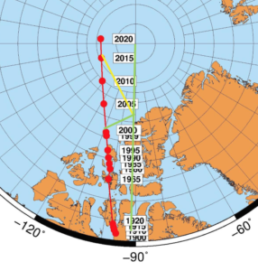
Yellow line is one of the 430 magnetic track (about 035)
I was flying more or less the 95 West meridian, so the magnetic North Pole was west of my position.
When I did compare the tracks, in my previous blog, it is clear that the heading to the 496 North (MH 094) and the 430 one (MH 070) were to be quite different. They were ¨pointing¨into a different point.
Even though the main point to be considered is the local declination, as explained by Pascal Groell, the reference to the respective North Pole was well away. The displayed values were right and now, it is easy to understand what was going on.
Both systems were working perfect before and after the North Pole. I have no idea about why they displayed curved paths into Svalbard after overhead the NP. No idea so far, why the 496 displayed a fan into Svalbard before reaching the NP.
The funny thing was, as explained, at the NP itself.
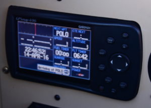
Have a look at the 496 data when approaching the NP: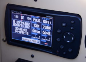
You can see that the 496 track near the NP is around 135
The Z time is 22:46-40
The flight time is 06:45
Speed 138 kts
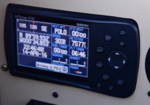
Now, the position is really close to the NP
Z time is 22:46-48 (eight seconds later)
Flight time is 06:46 (one minute later)
Speed 303 kts WOWWWWW ! The fastest RV8 !
Almost 100 ft away from the NP…
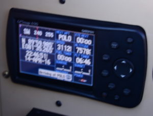
Z time is 22:46-51 (three seconds later)
Flight time is 0646…OK!
Speed 3112 kts 🙂 🙂 5760 kms/h FAI C1C speed world record !!!!
What a clean aircraft is my RV8, and flying almost level !!!!
Wow, wow, wow, wow and woooooooow !!!
But the airframe nose didn´t change, no tunnel vision, no magic lights…
And then:
No speed ????
Z time 22:46-52 (one second later)
Flight time: 0642
Flight time minus four minutes????
That remembers me Superman travelling through the time!
Where I was? May be a Santa Claus threat to confuse me?
North Pole is interesting: don´t you think so?
4 Comments
Dear Michel,
sooo, we had 2 problems.
Problem 1 is the magnetic pole drift and its consideration in the Garmin software. This is no factor indeeed, since you were travelling true north pole according to WGS84 satellite system coordinates supplied by GPS.
Problem 2 is the position calculation near the pole (x,y, and z) and all of its derivatives: speed and heading vector. Here, the problem arises due to the numerical precision of the Garmin processors. I assume that the one in 496 is less precise than in the 430 (a certified device), maybe 16 versus 32 bit or 32 versus 64 numerical precision. That explains different behaviour. Position 1 at time 1 (x1,y1,z1) could be sufficient precise very close to the pole, time received from the satellite actually is precise. Hence, position 2 at time 2 (x2,y2,z2) is equally precise very close to the pole, since within seconds the signal quality likely would not change.
Sooo, if you plot the two positions on a piece of paper map, you will get dead reconing position, direction and speed vector.
Buuuut, if Garmin calculates that using spheric trigonometric formula, the result is obviously at the limit of numerical precision, also reaching infinity. Thats what 396 shows with “———” fields and speed appraching light speed! Even worse, mapping software consecutively create several “solutions” plotted on the map: a fan.
Likely, the other device 430 does not do exactly the same, but has also no ideal solution for pole proximity.
Sun (if visible), paper map, position readings when GPS shows something, and pencil plot dead reconing would resolve these problems. (or better Garmin software…)
Right, my friend?
Hello Michel,
I had 5 GPSs on board when I crossed the North Pole. All, including a Garmin 496, showed accurate position but they all got confused as far as mapping. My solution was to use the old fashioned spinning mass gyro. I pre-set my outbound course on that and once I reached the pole flew that pre-selected heading. Once I was away from the pole by several miles, all of the GPSs behaved normally.
At least when you do the South Pole there will be visual clues in the form of Amundsen-Scott station. It looks like a junkyard at the end of the world. I can send you my photos if you like.
Bill
Hi Bill
Glad that you are here.
First of all, thank you for the many advices you have provided me before the flight.
Your round the world over the Poles is very important for all of us and I feel happy with your comment.
As I was telling Peter, the key is to know in advance and be prepared. I am in contact with Garmin and sure that they will have their systems updated according to our information.
Now it is time to prepare the next flight and go for it.
Best regards
Michel
Hi Peter
As I was taking pictures only to the 496, I cannot tell about what happened to the 430 before the GPS failure.
When I was young 🙂 I designed a software for navigation and have already had those ¨zeros¨ with spheric trigonometry at the equator and the poles.
I fixed that for the ¨zeros¨somehow just overriding the position. I wrote the program in Basic and still have it.
It is not a big issue if we know in advance about what is going to happen. It is not necessary either to fly just overhead.
Thank you Peter for your comments!!! And for your hospitality !!!
Michel
You must be logged in to post a comment.