


4WDs and 4LCs
I had to be early at the airport.
I wanted to check the aethalometer because I suspect it is not running properly.
Also, I was going to cross the desert, and temperatures are high there. As you know, any aircraft performance deteriorate with heat. Air density becomes lower, so the lift.
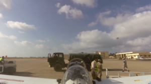
The taxi driver, who is the handling agent, and whoever knows what else, was right on time. Ten minutes later, we arrived at the airport.
M Matruh is really a military airport, opened for airliners only in summer. Airliners?
Yes, one per week !
Scattered private flights arrive there, just for business. So, I was the only one and have al the airport awake, to provide me customs and immigration.
I had to even remove my belt, because of a safety that I will never understand for a pilot going into his airplane. Also my bags were scanned.
You like photography, don´t you?. You have two cameras !
Noooo, I have much more in the bags !
Better to tell him in advance, would he don´t like my answer.
The fact is that during all my stay, everyone was kind with me, also at the airport.
I was not happy not to have my tail camera installed before departure. I was told that a pilot was held under police for more than 30 hours because of his go Pro camera.
The passport took almost one hour to be stamped, so I was cleared to go to the airplane and start preparing it. I was always escorted by a policeman, so it was not easy.
A few minutes, that same policeman had to go to the border of the ramp, and I was like a lighting installing the camera and then working in the airplane as a good boy.
Back in the airport, I was invited by the chief of the police there, to have a tea.
We had a nice chat (he spoke good english) but I told him that I should have taken off 10 minutes ago, and that my flight plan was valid 30 minutes….
Tea went fast into my stomach and after some hugs, I was on my way to the airplane.
Three or four came with me, and just, just, just when I was about to climb into the cockpit, one of them told the other…¨that is a camera.!.¨ pointing the tail camera.
Gasp !!!!
Big hugs, and even received a kiss. Indeed they are kind, and no longer the camera was mentioned again.
Soon I was cleared to take off and pointing to Alexandria.
You are cleared to FL 150 Cairo ATC said.
Cairo, EC XLL not able for FL 150, looking for FL 090
EC XLL cleared to FL 090!
I was concerned again with oil temperature, so this time, I climb at 300 feet per minute, and got save of the hot oil temperature ( but it raised to 230 F)
My communication is poor from the side, due to the belly tank. Better if the ATC station is at the nose, and much better when in the tail. So abeam Cairo, I was not able to communicate at 100 NM, not good.
They were patient, not a single complain.
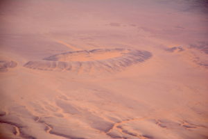
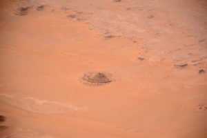
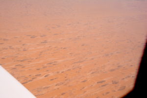
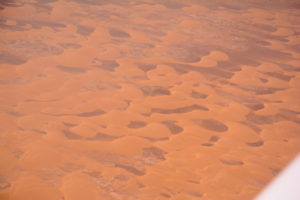
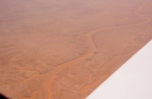
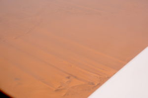
Desert is incredible. What a huge empty area!
Sometimes a road coming from nowhere was going nowhere. It crossed my path like a radial depicted in the ground ( radial , similar to wheel spokes, allows pilots to electronic know where they are relative to the transmitting station, for instance, you are in spoke 30, of a 360 spokes wheel, being spoke 90 the east).
Some of its surface was covered with sand, a yellow/orange sand. It should be difficult to maintain such long roads !
Of course, it had to happen :
EC XLL , Cairo, what is your estimate to Karthoum?
Cairo, EC XLL estimates HSSS at 1415 Z
EC XLL, do you have endurance to reach Karthoum?
Yes, Cairo, to reach Karthoum and three more hours reserve…
It took more comm exchanges to have them feeling better about my range.
Temperature up there was 22 C, and those 9000 ft, became 11500 ft density altitude ( that density altitude is the one that allows to know the true performance of the airplane, so for her, and my lungs, I was flying at 11500 ft).
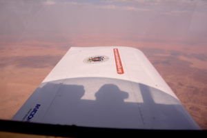
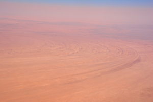
Soon I was entering sand in the air, lifted by thermals. Wind was not helpful, and reduced my groundspeed some 15 kts. Horizontal visibility was not so good, but vertical one was ok.
I could enjoy visiting the Mars countryside, from my own airplane, without flying a rocket for a full year.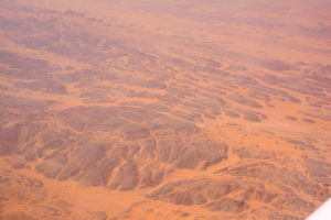
If someone wants to train for Mars, he could stay anywhere along my track. Not to forget that we are heading in that beautiful desert if we don´t care are global warming !
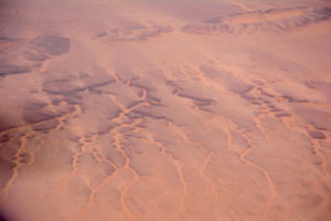
The view was astonishing. Sand, hills, dry river beds, geometric forms, artists ones…. a full rang of emotions and feelings that cannot been seen from a cruising airliner, or somebody driving a 4WD, or a 4LC.
I got you !
4LC stands for Four Legs Camel !
Desert looks sometimes flat, but I think that if I had to land on the sand, I would flip over, and it was no good.
Another kiss went to my dear airplane !
Approaching El Kharga made my mind think about the many places I was seeing, that still are untouched by the human kind. What a beautiful feeling !
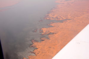
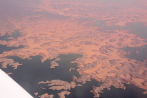
Soon Abu Simbel and the Nile were underneath, and I was approaching Sudan border.
Prevailing winds where easily seen on the ground. Long sand strakes were downwind of any vertical obstacle. But that north wind was not present in my flight ! What a pity.
I was tempted to go down and fly ground level, but it was to be so hot, and the next climb so hard, that I dismissed the idea.
Entering Sudan was like entering a dry lake bed. Absolutely flat, just some black hills from times to times. Even the sand color changed, turning closer to white.
Then I entered a huge thermals area. At 9000 ft they were really large and it was necessary to be very careful. Not with the turbulence (that was light) but with the speed.
Aircraft stall speed increase with altitude, and I was really flying at 11500 ft….
Autopilot is a nice feature, but when vertical drafts exists, and the autopilot is set to maintain an altitude, it is ok when the draft is upwards, as the aircraft tries to descend to maintain altitude ( look for speed to going overspeed, of course).
But it is dangerous when the next mass of air is going downwards. Aircraft descends, but autopilot tries to maintain the altitude, so angle of attack increase, speed gets lower and lower and can easily have your stalling or going into a spin.
As you see, no rest !
Sun was going down as I was approaching Karthoum
Communications were poor, but I was able to know from other aircrafts readbacks, the runway in use. Fortunately there was just one standard approach when coming from north, and I prepared for that one, would I not be able to communicate.
Was a good choice and when closer, I got good contact and was cleared direct to ILS rwy 18.
The heat was becoming intense in the cockpit, and some 1000 ft AGL (Above Ground Level), my OAT (Outside Temperature Indicator) was showing 45 degrees Celsius.
Again thin air over the runway: watch up. Michel !!!!
Increase approach speed, set medium flaps, and fly with power into the runway !
Of course, a small bounce, but the aircraft was safe in the ground.
A huge long back track in the runway, with an unhappy airliner full landing lights into me, on final.
I can tell that his behavior helps to increase the back track speed, but also sure that if necessary (not going to reach take off speed) , i would have him going around !!!
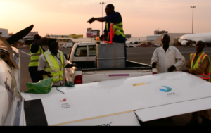
Arrived at the parking position, in between non flyable aircrafts, soon I was received by a truck with the fuel: 200 liters avgas (some $1100) and the rest, Mogas.
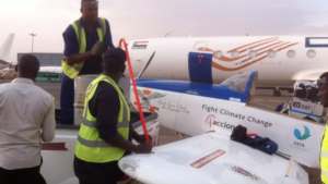
It was a good moment, and again, all people were kind and helpul. Sudan: a new world for me !
2 Comments
Great photos of the dessert Michel! It IS just like Mars. Red sand, barren, no signs of life at all. I sure am glad your contraband cameras were not confiscated!
I will do the math for the followers of the this flight: 1 liter of gas costs $5.50. One gallon of gas costs $20.35!! I hope you know now how much your contributions to this flight is appreciated! If you have contributed we thank you very much. If not, we urge you to help support this important mission with any donation you can. Thank you so much for following this historic mission.
Don Pearsall
Sky Polaris Administrator
Congrats, Michel!
Wonderful pics. I followed you in Google Earth and the Spidertrack map. It doesn’t show these pretty details.
Windity showed the strongest headwind component just at your altitude. I guess cruising at 5-7 thousand where the winds were shon to be calm would have been too hot or sandy?
All the best for the next leg, blue and unsandy skies!! Peter
You must be logged in to post a comment.