


Natal to Belem
Time to leave
Yes, time to depart has arrived. It is a difficult task because many good things are left.
I have been cocooned since I have arrived, both by the family of Luiza (the wife of my friend Guillermo), and by Almir.
Everything I would need, they were ready to provide it.
Usually, in my other flights (2009 and 2001), I have lost a lot of weight.
The actual pacing is quite different. So many picañas, shrimps , cocadas and other prohibited items, really stick around. But…¨God saves the King ¨, or in spanish ¨todo por la Patria¨!
It is true that the distance between Paula and myself helps a lot, and it is easier not to feel guilty.
Besides…the Center of gravity of the airplanes improves ! It cannot be in a different way. Pure physics !
So, thank you all and so much ! I hope meeting us again soon !
Yesterday I filed a flight plan to SWEQ ( Belem Aeroenautico) and went to bed early.
Somebody called in the night, but I kept resting.
Actually the call was from Rocket Route Team, to provide me more information about missing items in my flight plan (according to Brasilean Regulations). Also I was requested to add a scanned signature in my Operator Profile.
I am glad with the kindness and good job Rocket Route is providing.
Another message was sent: SWEQ was closed !!! Just a few days ago..
Fortunatly Almir came to pick me up and helped me. I decided to change my destination to SBJC, so once decided, he called the airport and filed the flight plan.
Once we arrived into the airport, It took a long time to refuel and have everything ready, so finally I was quite late from schedule (and I knew that it is not good to arrive late at Belem.
Time of a big thank you and good bye.
Natal did receive my call from the ground (not as easy) and I was cleared for take off.
I decided to change the storage place of my emergency solar panels, from my right side into my left side were more room was available.
The engine check was ok at 2000 rpms, so I pushed the throttle forward for full power.
The power was not coming.
I had the feeling that the throttle didn´t reach the full forward position and that was true.
The solar panels avoided that movement because it was on the way of the rear (copilot) throttle control.
Take off was aborted !
I thought about what would have happened. You now: if you take an action and something goes wrong, you have to step back.
If you lower the flaps and the plane rolls, you have to invert that selection…
Once I got full movement, I firewalled it and soon I was climbing.
Speed was low, so my rocking the wings to say goodbye was quite conservative.
Runway heading until 3000 ft (converging traffic) and right turn towards Belem.
I got nice tailwinds, fortunatly because the airplane was not flying fast.
The more I fly the RV, the more I feel that altitudes of 7000 to 8000 ft are better. Indicated speeds versus power are the same, but true airspeeds are much higher, and during long flights, eight or ten knots mean 30 to 45 minutes difference.
Soon I was transferred to Recife control: EC XLL, you are not flying the correct altitude ! ( it was the one provided by Natal). You have to go even altitude plus 500.
No problem, Recife. Is 4500 ft right for you?
Yes EC XLL, climb to 4500 ft!
Also I was provided Transamazonia frecuencies, would I loose contact with them (128.3, 126.15 and later on, 133.7).
Flying so low over so big distances leads to that: no contact with anybody!
When I fly, I like to enjoy the scenery. I do know that what I see, I will never see it again.
I look for features, for life, for barren, for people. I try to take some pictures and video. I write some comments for later, and finally, if I remember, I ……manage the fuel ….!
Something that I have not liked since Dakar is the fact that, as stated, flying low reduces drastically the range of VHF communication. We, pilots, solve from times to times the problem using other aircraft as a ¨relay¨ station.
That means that I am able to contact another aircraft in flight, that also is in contact (because of its altitude) with the control center. So, the procedure is to call that aircraft and ask him if they can relay my message (position report or whatever) to the Air Traffic Controller.
During the crossing of the Atlantic, I tried many times to call on 121,5. That is an emergency frequency also used for this purpose as it is always a good advise to listen to it.
Long range airliners use to listen to it, but……not every one answered my calls.
Who is going to call in the middle of the ocean??? Why to open the frequency?
So nobody answered to my calls and I had to manage with my Iridium Satelite phone (gracias Juan!).
It also happens (over land) that my call can be listened by the ground station, but not the contrary. In that case, we use another technique: transmitting blind.
Fortaleza, EC XLL, EC XLL transmitting blind. Position (whatever it was), FL045, estimating Eliet at (whatever it was).
It it a courtesy from listening aircraft in that very same frequency (Fortaleza one), to offer himself as relay station. Not a single one of them did !
The scenery started with huge farmer lands, almost the first part of the flight. Flat lands with plenty of places for unscheduled landings. From times to times, an airfield, an asphalt one, or dirt one or gravel one was in view. Isolated airfields in the middle of nowhere with a home or buildings or without (just the runway).
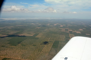
Then some small pyramid shaped hills rose from times to times from the flat land.
Near Quixada, the ceiling (base of the clouds) was more or less at my level, so I crossed many clouds that were going to grow up later.
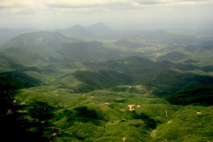
Land changed to some more hilly and even one crossed very close my altitude (good to be watching outside !).
Also the colour changed into green. Emergency places to land started to be scarce but I really enjoyed the moment because very few people lived down there. Groups of three or four houses (modern construction with orange tile roofs), linked by long dirt routes, scattered underneath the wings of my dear RV. I wondered how was the life of their inhabitants as they were so far away of other human kind people.
In one of these road I tracked somebody driving its (I think) motorbike. May be it was a speedy bicycle (a world champion), but if not, how would him get the fuel?.
Some fires (small) were also in sight. They looked small and human produced may be to burn dried wood- I don´t know !.
As I crossed the path of the rising smoke, I tracked the position for the CEAMA to know. The aethalometer is very sensitive and it is important to register that information.
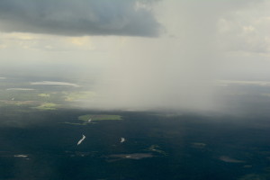
Of course, those Cumulus congestus converted into towering cumulonimbos.
The vertical updrafts or thermals helped me at the beginning. I got ground speeds up to 180 kts (333 km/hrs).
The showers started to be intense. I started to deviate and avoid them. Showers and downdrafts are together, so better to turn around.
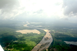
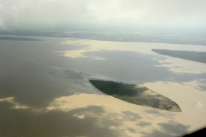
Then I was already south of Sao Luis, scenery changed and again farmers lands came into view at the beginning and then converted into swamp lands and huge rivers.
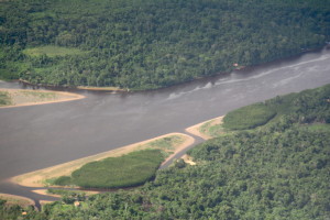
I imagined landing there and fighting with turkey sized mosquitoes and spaniards eating anacondas
As you see, flight drives nuts !
Then thunderstorms become to be serious. Airliners deviating.
EC XLL, Belem, your destination airport is close, poor visibility and showers. You cannot land there. What airport you will like to deviate ?
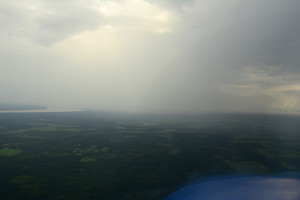
Belem, EC XLL, I will hold east of the airfield until weather improves.
EC XLL, Belem, what it your endurance?
Well…around four hours starting now!
(what a privilege, all the other airliners just had 30 minutes ! 🙂
But I just needed to turn two or three times. Thunderstorms move and it was just a matter of time.
I was vectored to the airfield and once in visual contact, I was switched to the control tower. Cleared for a left downwind, I was informed of a four knots wind at landing.
May be at landing, because in final, I had to offset some 30 degrees away from the runway heading to fight the wind at 800 ft.
The runway was damp and the draining was not good (it was a surprise at an airport with plenty of rain during the year). Some of the wheels suffered aquaplaning but the aircraft was kept under control.
Brigadeiro Protasio de Oliveira airport (SBJC) is plenty of general aviation aircrafts, so a good place to stay.
I had to fix now some items in the plane, not relevant but one: the ¨toilet¨one that has became inoperative and is not draining. The venturi probe has departed (it was not safety wired) so now I have to find a fitting and install it.
Just imagine what can happens if you not have where to store that kind of thing or drain it !!!
3 Comments
Reciclage? combertirlo en combustible alternativo dentro de unos años?
Cariños.
Me alegro de que disfrutes de la gastronomía brasileña!
Bonitas fotos! nos acercan a tu aventura! Gracias!
Pero mira que eres tripero; aunque Brasil es un país grande y que produce muchos alimentos como no levantes pronto el vuelo lo vas a dejar devastado, alimentariamete hablando se entiende. Disfruta y crea reservas nutricionales ahora que tienes buenos y generosos amigos que “luego vendrá el tío Paco con la rebaja”. Además de las excelentes fotos de los paisajes, también podías enviar fotos de esos manjares.
Un fuerte abrazo.
You must be logged in to post a comment.